 Get premium membership
 and access revision papers with marking schemes, video lessons and live classes.
OR
Processing. Please wait.

Form 2 Geography Online Lessons on Internal Land Forming Processes
Lesson on Features Resulting From Faulting
(16m 19s)
Download as pdf file
Answer Text:
Features Resulting From Faulting
Fault Scarp/Escarpment Steep line of slopes formed by vertical movement of earth along a fault e.g. Mau, Nguruman, Nyandarua and Nandi.
-Are exposed parts of a fault plane. It may be formed due to normal faulting or reverse faulting when overhanging blocks are eroded.
Fault Steps
- Land resembling the staircase or steps of a house with a series of fault scarps at different levels.
• Parallel vertical faults develop.
• Land between the faults is unequally displaced downwards.
• A series of fault scarps at different levels is formed.
-E.g. Keiyo escarpment and at Kijabe. Fault Blocks/Block/Horst Mountains
• Blocks of land raised above the surrounding land.
• Where tectonic forces cause faulting and land on one side of the fault get raised or sink along the fault planes.
Examples of fault blocks are Aberdare/Nyandarua ranges, Mau escarpment and Nandi Hills.
• Where Blocks of land bordered by normal faults which are almost parallel to each other sink leaving the middle block standing. Examples of horsts are Ruwenzori of W. Uganda and Usambara and Pare mountains of Tanzania.
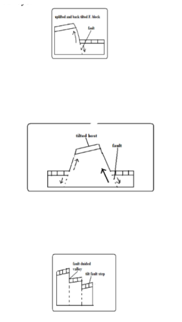
Tilt Blocks
- Fault blocks which are inclined on one side.
• Occurs when the fault block, horst or fault steps have
greater uplift on one side and as a result they are not flat at the top but tilted.
The resultant features are tilted fault blocks, tilted horst and tilt fault steps which form ridges and fault guided valleys.
Rift Valley
-Along narrow trough with steep escarpments on both
sides.
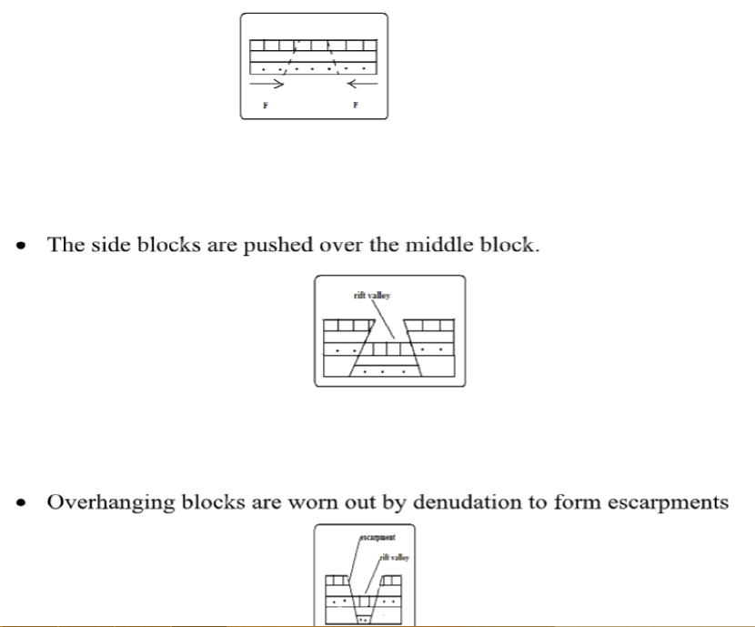
Theories of Formation
Tensional Theory
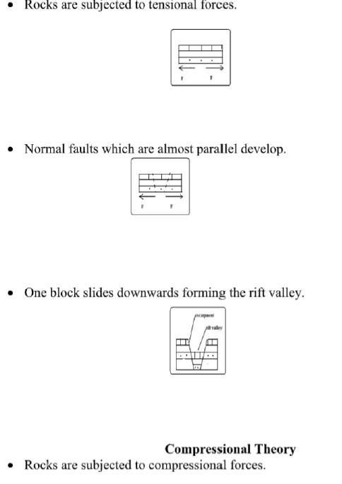
• Reverse fault which are Almost parallel develop.
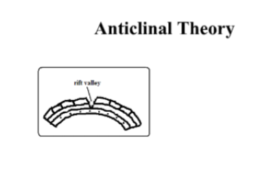
Suggests the rift valley was formed by Anticlinal arching.
• Upward forces pushed sedimentary rock strata upwards.
• The rock layers bent into a big arch.
• A gaping/huge crack developed at the crest of the arch due to tension forming the rift valley.
The Great Rift Valley/The Great E.A Rift Valley
- The world’s biggest rift valley.
It starts in Syria and ends in Mozambique.
It’s divided into 4 parts.
1. Ethiopian Rift system-starts from Afar in Ethiopia to the Kenyan border around L. Stephanie.
2. Gregory Rift system-Starts from the northern border of Kenya with Ethiopia to Tanzania.
It has a small N.E-S.W branches:
• Kano Rift valley in Kenya
• L. Eyasi Rift Valley in Tanzania
3. Western Rift valley-Starts at Sudan border to south of L. Rukwa.
Features which are here are Ruwenzori Mountain and Lakes Albert, Edward, Kivu, Tanganyika and Rukwa.
4. Malawi Rift valley-a continuation of Gregory Rift system to Zambezi River in Mozambique. It has a small N.E-S.W branch called Luangwa valley.
The Gregory Rift Valley
-Named after a geologist called Gregory J.W who carried out extensive studies in this area. It’s where the Rift Valley features are more pronounced.
Features associated with it
• Fault blocks-Aberdare range, Mau, Nandi and Cherangani hills.
• Step faults-Kijabe and Tambach
• Tilt blocks-Aberdare range uplifted and tilted eastwards
and Mau escarpment uplifted and tilted westwards.
• Lava flows and volcanic cones e.g. Menengai and Ngorongoro crater.
• Rift Valley lakes formed when unequal sinking created faults which were later filled with water. The lakes are deep and elongated. Examples are Lakes Naivasha, Nakuru, Elementaita, Baringo, Bogoria, Ol Bolossat and Turkana. Most of the lakes are salty with exception of L. Naivasha which has fresh water.
Why Most Rift Valley Lakes Are Salty
(a) Lack of outlets to drain away salts contained in them.
(b) Lack of enough water to dilute salinity due to little rainfall and lack of rivers flowing in them.
(c) High rates of evaporation causing increased accumulation of salts.
(d) Lake’s water being in contact with rocks with mineral salts which it directly dissolves.
(e) Washing into the lake of mineral rich soils by surface runoff.
Why L. Naivasha Has Fresh Water
(a) It has underground drainage to the Indian Ocean.
(b) There is inflow of fresh water from rivers and rain.
(c) The latest volcanic eruption covered the bed rock with lava.
Major Faulted Areas of the World
(a) The Great Rift Valley from Syria to Mozambique.
(b) Northern England and the Great Glen Fault of Scotland.
(c) The Central Massif of Europe.
(d) The middle Rhine Rift Valley region.
|