 Get premium membership
 and access revision papers with marking schemes, video lessons and live classes.
Form 3 Paper 1 Geography End of Term 2 Exams 2021
Class: Form 3
Subject: Geography
Level: High School
Exam Category: Form 3 End Term 2 Exams
Document Type: Pdf
Views: 683
Downloads: 9
Exam Summary
312/1
GEOGRAPHY PAPER 1
TERM TWO 2021
2 ¾ Hours
INSTRUCTIONS TO CANDIDATES
(a) This paper has two sections A and B.
(b) Answer all questions in section A.
(c) Answer question 6 and any other two questions from section B
(d) All Answers to be written on booklet provided
(e) Candidates should check to ascertain all questions are printed
(f) Candidates should answer the questions in English.
SECTION A
ANSWER ALL QUESTIONS
1. (a) Identify two types of environment (2mks
(b) mention three areas covered in physical geography (3mks)
2. (a) State components of the Solar system (3mks)
(b) List planets in the solar system without satellites (2mks)
3. (a) Mention types of folds (3mks)
(b) Name fold mountains found in the following continents (2mks)
.(a) South America North Africa
4. Define the tem Earth movement (2mks)
(b) State three causes of earth movement (3mks)
5. (a) Define the following terms
(i) Divide/watershed (1mk)
(ii) Confluence (1mk)
(b) Identify ways in which a river eroded its channel (3mks)
SECTION B
Answer question 6 and any other two questions
6. Study the Migwani Map sheet 151/1
Scale: 1:50000 and use it to answer the questions
(a)(i) State types of scales used on the Map extract (2mks)
(ii). Name two man-made features found East of Easting 00 and north of Nothing 80 (2mks)
(iii). Give the six figure grid references of Kauma dam top the South West of the Map extract. (2mks)
(b)(i) What is the length in kilometers of all weather road Bound surface C94 from the junction with the Dry weather Road D502 to northing 84? (2mks)
(ii) Calculate the area enclose by all weather loose surface road to the North West of the Map. Give your answers in KM2
(iii) Draw a square 14cm by 14cm to represent a section of the map enclosed by easting 99 and Northing 70 on it mark and name the following features.
(a) Mboni Dam
(b) Dry weather road south of Northing 91
(c) Iko shops
(d) River ngoo (5mks)
(iv) Citing evidence from the Map, give three functions of Gwani town. (3mks)
(a) (i) Identify two types of vegetation found North of Northing 68 (2mks)
(ii) describe the drainage of the area covered by the Map (5mks)
7. (a) (i)What is a rock? (2mks)
(ii) Give two types of intrusive igneous rocks (2mks
(iii) State three characteristics of Sedimentary rocks (2mks)
(b) The table below shows some original rocks Name their metamorphic equivalent
(Original rock) Metamorphic
Granite …………………………………………. (1mk)
Sandstone …………………………………………. (1mk)
Clay …………………………………………. (1mk)
Limestone …………………………………………. (1mk)
(c). Describe three ways through which original rocks turn into metamorphic rocks (6mks)
(d).You are supposed to carry out field study on rocks around your school
(i) Give two methods of data collection you would use (2mks)
(ii) State two objectives of your study (2mks)
(iii) Give reasons as to why it would be necessary to carry geological hammar (1mk)
(iv) State three problems you are likely to encounter in the course of the field study (3mks)
8. (a) Define physical weathering (2mks)
(b) Describe three processes of physical weathering (6mks)
(c) (i) Explain two factors which accelerate the rate of weathering in equatorial areas (4mks)
(ii) Explain three significance of weathering to human activities (6mks)
(d) You are planning to carry out a field study on weathering in the area around your school
(i) State two ways you would prepare for the study (2mks)
(ii). Give three chemical weathering processes you are likely to study (3mks)
(iii).What follow-up activities would you be involved in after the field study (2mks)
9. (a) (i) What is faulting (2mks)
(ii) Name four types of faults (4mks)
(b) (i) State three causes of faulting (3mks)
(ii) Using well labeled diagrams, describe the formation of rift valley by compressional forces (6mks)
(iii) Apart form Rift Valley name three features formed by faulting (3mks)
(c) You intend to carry out a field study on faulting at the Rift Valley.
(i) Identify four sources of data you would use prepare for the study (4mks)
(ii) State three positive effects of faulting to human activities you are likely to identify (3mks)
10. (a) (i) Differentiate between weather and climate (2mks)
(ii) Identify any three elements of weather (3mks)
(b) State the apparatus found in Stevenson screen (3mks)
(c) The table below represents temperature and rainfall data of a certain station. Use i to answer question c(i) (ii) (iii)
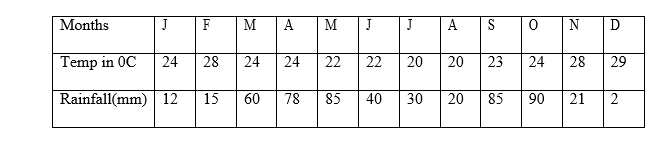
(i) Calculate annual range of temperature (show your calculations) (2mks)
(ii) Calculate annual rainfall (2mks)
(iii) Describe the climate of this station (5mks)
(d) (i) What’s weather forecasting (2mks)
(ii) State effects of weather furcating on human activities (3mks)
(iii) List factors that influence temperatures of a place (3mks)
More Examination Papers