 Get premium membership
 and access revision papers with marking schemes, video lessons and live classes.
Form 3 Geography Paper 1 End of Term 3 Examination 2021
Class: Form 3
Subject: Geography
Level: High School
Exam Category: Form 3 End Term 3 Exams
Document Type: Pdf
Views: 1070
Downloads: 16
Exam Summary
TUTORKE EXAMS
312/1
FORM THREE
GEOGRAPHY
PAPER 1
END OF TERM THREE EXAMINATION 2022
TIME : 2¾ HOURS
NAME-------------------------------------------------------- ADM NO------------------
DATE:……………………………………………………………SIGN………………………….
INSTRUCTIONS TO CANDIDATES
i. This paper consists of two sections; section A and section B.
ii. Answer all questions in section A. In section B answer question 6 and any other two questions.
iii. All answers must be written in the answer booklet provided.
iv. Candidates should check to ascertain that all pages are indicated and that no question are missing
SECTION A: ANSWER ALL QUESTIONS IN THIS SECTION (25MRKS)
1. a) A part from planets, name two other members of the solar system (2mks)
b) State three characteristics of planets (3mks)
2. a)Name the three main layers of the atmosphere from the earth’s surface upwards. (3mks)
b) State two ways in which the atmosphere is heated up (2mks)
3. a)Distinguish between minerals and rocks (2mks)
b) The table below shows types of sedimentary rocks. Name the resultant rocks that forms after metamorphism (3mks)
Rock ........ Metamorphism equivalent
v. Sand stone --------------------------------
vi. Limestone --------------------------------
vii. Clay -------------------------------
4. a)Distinguish between vulcanicity and volcanicity (2mks)
b)State three characteristics of basic lava domes (3mks)
5. a)State two sources of underground water (2mks)
b)Give three factors which influence the formation of features in limestone
areas (3mks)
SECTION B
ANSWER QUESTIION 6 AND ANY OTHER TWO QUESTIONS FROM THIS SECTION
6. Study the map of Busia (1:50.000) sheet 101/1 provided and answer the following questions
A. i) Give the latitudinal and longitudinal position of South East corner of the map (2mks)
ii) Give two methods used to represents relief on the map (2mks)
B. i)Calculate the area enclosed by the international boundary and Northing
40 up to the western margin of the map .Give your answers in Km² (2mks)
ii)What is the length of the loose surface road c 526 from the junction near Odiado school, grid reference 276318 to the end of the map on the East end ?(2mks)
iii) Give the bearing of the road junction at Matayo from the air photo principal point in the Grid square 3141. (2mks)
c) Draw a square measuring 10cm x 10cm to represent the area from Easting 20 to 25 and Northing 28 to 33.
On it mark and label
i. Swamp
ii. A road C523
iii. River Wakhungu
iv. Thicket (6mks)
v.
D. i) Describe the drainage of the area covered by the map (5mks)
ii) Citing evidence from the map give two economic activities used in the area covered by the map (4mks)
7. i)Differentiate between weather and climate (2mks)
ii) State three characteristics of the inter-tropical convergence zone (I.T.C.Z ) (3MKS)
b).The diagram below shows climatic regions of Kenya. Use it to answer questions which follow.
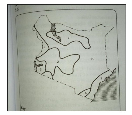
i) Name the climatic regions marked 1,2 and 7 (3mks)
ii)State the climatic characteristics of the region marked 3 (4mks)
c).Explain how the following factors influence climate
i) Altitude (3mks)
ii) Ocean currents (3mks)
d).Students of Wako secondary school carried out field study on a weather station
near their school.
i) Name three instruments that they are likely to identify in a weather station (3mks)
ii) State two reasons why they need a pre-visit before they set out for the study (2mks)
iii) Name two methods they would use to collect the data during the study (2mks)
8. A. i)Define the term catchment area (2mks)
ii) State four features which results from river erosion (4mks)
bi)Differentiate between river capture and river rejuvenation (3mks)
ii)Name three features resulting from river rejuvenation (2mks)
c).Explain four ways in which the river transports its load (8mks)
d).Using diagrams describe the following drainage patterns
i) Centripetal (2mks)
ii)Radial (2mks)
iii)Dendritic (2mks)
9. a. i)Define an ocean (2mks)
ii) List three types of tides (3mks)
bi).Name and describe two processes of wave erosion (4mks)
ii).The diagram below shows features resulting from wave action .Use it to
answer questions which follows
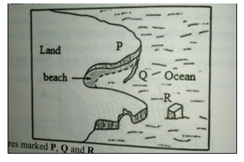
b) Name the features marked P,Q and R (3mks)
c) Describe how a wave cut plat form is formed (5mks)
ii) State two types of submerged highland coast (2mks)
d) Explain the significance of oceans to human activities (6mks)
10. a i)Distinguish between aridity and desertification (2mks)
ii) Identify two types of desert surfaces (2mks)
iii) Give two reasons why wind action is most active in hot deserts than in cold deserts (2mks)
b)Explain the following processes of wind erosion
i)Abrasion (2mks)
ii)Deflation (2mks)
iii)Attrition (2mks)
c.(i)State two factors that influence the transportation of material by wind in deserts (2mrks)
ii) Using a well labeled diagram explain the formation of a barchans (5mks)
d) Explain three significance of desert features to human activities. (6mks)
More Examination Papers